|
TRIAD for
WINDOWS
Survey Retracement & Analysis Software
Typical
Applications
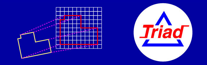
BOUNDARY RETRACEMENT - When a retracement
of a previous survey is required, existing monuments must be
verified and lost monuments replaced. If a map or deed exists
for which some corresponding monuments have been found in the
field then it is possible to analyze how the found monuments
relate to the map. A field survey is performed locating existing
monuments from which coordinates are calculated for the monuments
based on the field measurements. The map may be calculated on
some arbitrary coordinate system based on the record bearings
and distances. This establishes map coordinates at the corners
and verifies the mathematical correctness of the map. The points
and the map points are now available on unrelated coordinate
systems with a dual set of point numbers for common locations.
All of the points from the two systems are combined in a
coordinate data text file.
Run the Triad program and enter the point numbers of
corresponding locations. Triad will pair up the coordinates
of the map points with the coordinates of the found monuments and
instantly find the best fit for rotation, scale, and translations.
The solution for the transformation will indicate the best rotation
between the map and the field survey and the best scale factor to
be applied to the map distances that correspond to the field
measured distances. You may then analyze the residuals, use the
error detection routine, reject bad monuments, and re-process the
solution as necessary. After a solution is determined that
represents the best retracement of the survey, Triad can
create new points by transforming all of the points from the map
to the field survey coordinate system. Alternately, the field
coordinates may be best fit to the map.
CORNER SEARCHING - In the course of a BOUNDARY RETRACEMENT, as
described above, it may be helpful to use the found monuments to
develop search areas for monuments not yet located. Triad
will allow you to estimate the accuracy of the search area from the
Radial Standard Deviation.
PUBLIC LAND SURVEYS - Triad can be used in the
retracement of sectionalized lands to determine the proportional
length of the government chain and the deviation of the compass
(known as indexing). This may be very useful for estimating the
proximity for corner searching. Note, calculate the map (plat)
coordinates in chains then the resulting scale factor determined
by the program will be equivalent to the length of the government chain.
GRANT BOUNDARY ADJUSTMENT - Triad automatically
performs a Grant Boundary Adjustment as described in the Manual
of Instructions for the Survey of Public Lands when new points
are calculated that begin and end at two fixed points in a solution.
Triad will rotate, translate, and proportionately adjust
record measurements in the same manner as prescribed for public
land surveys.
GPS & CONVENTIONAL CONTROL SURVEYS -
Adjusting field measurements to fit existing control points without
verification may distort good work. Avoid this by computing a
minimally constrained adjustment of the field measurements to
obtain preliminary coordinates. Then, use Triad to fit
these coordinates to the published or accepted coordinates of
found control points to verify consistency and check for problems
before performing a constrained adjustment.
SUBSIDENCE & EARTH MOVEMENT - Establish a control network
outside of the study area on stable ground. Perform a field
survey from time to time locating the monitoring points to track
subsidence relative to the outside control network. Using
Triad, fix the outside control and set the monitored points
inside the study area free. Compute a transformation solution to
fit earlier observed positions to later observed (new positions)
of monitored points. The actual movement of the monitored points
will be indicated by the residuals.
DATUM TRANSFORMATIONS - Use Triad to compute local
transformations in state plane coordinates from the North American
Datum of 1927 (NAD27) to North American Datum of 1983 (NAD83).
Assuming sufficient common control points, this will provide an
accurate and quantifiable solution.
GIS - Use Triad to create a
mosaic of parcels by hooking subdivision maps and boundary surveys
together via common points. Then, constrain the composite mosaic
to best fit known ground control.
Triad can determine the positions on a best fit straight
line for a row of monuments.
SYSTEM REQUIREMENTS:
SYSTEM REQUIREMENTS: WINDOWS XP, Windows 7, 8.1, and 10 - PURCHASE
PRICE $445.00
COPYRIGHT 1990-2017 MCGEE SURVEYING CONSULTING
michael@sbcoxmail.com
Tel. 805-964-3520
|