|
TRIAD for WINDOWS
Survey Retracement & Analysis Software
General Description
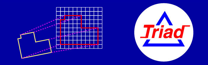
OVERVIEW: Triad is a very unique tool
that allows surveyors to best fit a map, deed or coordinate system
to an unlimited number of known points in considerably less time
than any other method. Triad will perform an analysis of all points
common to two coordinate systems accurately, easily and quickly.
The more points in a solution, the better it works. Triad is a
powerful program that is simple to learn, organizes and documents
the process of analyzing a survey retracement. The surveyor can
focus on professional judgment, not the tedious task of crunching
numbers and comparing record verses measured data. The results are
summarized with statistics.
TYPICAL BOUNDARY RE-TRACEMENT APPLICATION:
It is a well-known principal that the intent of a boundary
retracement is to re-establish the lines and corners of a prior
survey in their most probable original locations. A common
method of analysis uses coordinates to compute the inverses or
connections between found monuments and compare the inversed bearings and
distances with the corresponding inverses on a plat or map. If the
inverses are consistent in rotation and distance then those
monuments may be acceptable for re-establishing the boundary. This
process becomes more difficult to organize and quantify as the
number of points increase. For example, four points have six
possible inverses. Eight points have 28, doubling to 56 inverses
when comparing the map points with the field points. The time spent
analyzing found monuments in this way is time consuming and costly.
Triad is a productive and efficient solution for handling
this problem.
HOW IT WORKS: Triad works by determining
the four parameters of a two- dimensional transformation: rotation,
scale and translation. These are solved simultaneously by best
fitting the points in one coordinate system to the same points in
a second coordinate system. The points in the first system are
treated like a figure, the angular relationship between points is
retained while the figure is scaled, rotated and shifted to best
fit all the points in the second system. New coordinates can be
computed for the boundary based on a best fit of all acceptable
monuments. Alternately, if one prefers, the two best points can be
fixed. A summary report is created for the job file.
ERROR TRAPPING: The preference in retracing
another survey is to quickly identify acceptable monuments. A
unique feature of Triad is its optimized Blunder Detection
Routine. This routine will instantaneously identify individual points
contributing the greatest errors when fitting one system of
coordinates with common points to another. Simply remove the
unacceptable points to obtain the best solution.
SUMMARY: Triad is used when it is necessary
to relate different coordinate systems with two or more points in
common. Triad provides a rigorous approach for an accurate
conversion of local coordinates to a different system or, state
plane coordinates from NAD27 to NAD83. for control surveys, use it
to compare the new measured positions with previous coordinates to
get "tied-in" to an existing survey instantly with confidence based
on the residuals listed for each point in the solution. Use it to
estimate the compass and chain index necessary for retracement of
ancient GLO surveys. In GIS applications, it is great for hooking
record maps together to build a mosaic. Triad has been in
wide use in the US and around the world since 1991. Developed by a
GPS/GNSS Consultant, geodesist and licensed boundary surveyor with
over 30 years' experience. There is no exaggeration to the statement
that an analysis performed with Triad will accomplish in
seconds, what otherwise can take hours!.
SYSTEM REQUIREMENTS:
SYSTEM REQUIREMENTS: WINDOWS XP, Windows 7, 8.1, and 10 - PURCHASE
PRICE $445.00
COPYRIGHT 1990-2017 MCGEE SURVEYING CONSULTING
michael@sbcoxmail.com
Tel. 805-964-3520
|