|
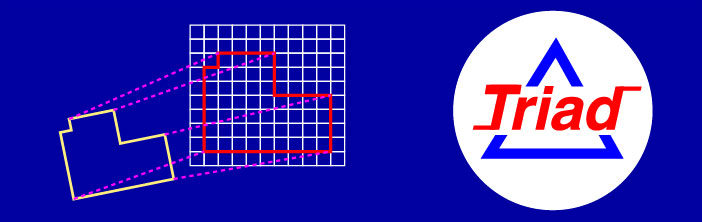
Example of a Triad Solution
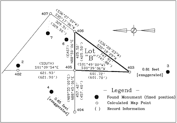
A boundary survey is required of Lot "B" (below)
to re-establish the missing corners. The coordinates of the map
corners and the found monuments are retrieved from an ASCII (plain
text) data file. See the following explanation of a sample printout
(the Program Manual contains a detailed example)
********************** STEP ONE: INITIAL SOLUTION *********************
The record map is best fit to the five found
monuments using the coordinates of common points. The largest
error or residual is from the calculated position of #403 to the
found monument #3 shown below as *181° in azimuth (S 1°W) 0.81'.
The best rotation and scale is determined with a 68% probable
error indicated by the Standard Deviation.
|
Map Pts
|
Field Pts
|
Rectangular Differences
|
Polar Differences
|
|
System 1 to
|
System 2
|
North (Lat)
|
East (Dep)
|
N. AZIM
|
DIST
|
|
"402
|
"2
|
"-.004
|
"+.104
|
"92°
|
".104
|
|
"*403
|
"3
|
"-.809
|
"-.010
|
"*181°
|
"*.809
|
|
"404
|
"4
|
"+.475
|
"+.447
|
"43°
|
".653
|
|
"406
|
"6
|
"+.225
|
"-.137
|
"328°
|
".263
|
|
"407
|
"7
|
"+.113
|
"-.404
|
"286°
|
".419
|
Standard Deviation of the latitudes and departures = 0.39 |
|
Scale Factor = 1.00004129 |
Standard Deviation = .00038340 |
Rotation = - 1° 09' 54.3" |
Standard Deviation = 0° 01' 19.1" |
********************* STEP TWO: BLUNDER DETECTION*********************
This option determines the largest error that
would remain after rejecting each of the found monuments indicated
below. Rejecting #3 will reduce the largest error in the Initial
Solution from 0.81'at #3 (above) to *0.13' at #6. The rotation
and scale that would result follow on the same line.
|
REJECT
POINT #
|
MAXIMUM RESIDUAL
|
ROTATION
|
SCALE
|
|
N. AZIM
|
DIST -> PT #
|
|
2
|
181°
|
.79
|
3
|
-001° 10' 07"
|
1.000059
|
|
* 3
|
138°
|
*.13
|
* 6
|
-001° 09' 29"
|
.999336
|
|
4
|
88°
|
.45
|
2
|
-001° 10' 50"
|
1.000368
|
|
6
|
180°
|
.72
|
3
|
-001° 09' 42"
|
1.000090
|
|
7
|
181°
|
.66
|
3
|
-001° 09' 21"
|
1.000237
|
* It can be seen by inspection that the best solution
will be obtained after rejecting #3. Triad will automatically
search and report this fact.
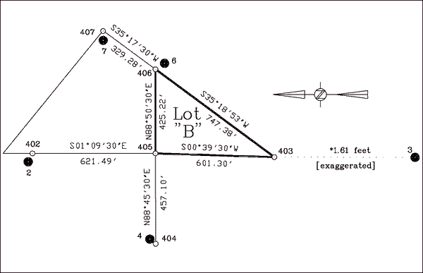
********************* STEP THREE: FINAL SOLUTION ********************
Point #3 is rejected by setting the pair 403,
3 "FREE". The solution is re-computed to best fit the
remaining monuments. The calculated corner positions now fall
between 0.06' to 0.13' of the found monuments as shown below.
|
Map Pts
|
Field Pts
|
Rectangular Differences
|
Polar Differences
|
|
System 1 to
|
System 2
|
North (Lat)
|
East (Dep)
|
N. AZIM
|
DIST
|
|
402
|
2
|
+.055
|
-0.055
|
314°
|
0.08
|
|
403
|
3
|
-1.611
|
-.021
|
180°
|
1.61 FREE
|
|
404
|
4
|
+.037
|
+.049
|
53°
|
.06
|
|
406
|
6
|
-.096
|
+.085
|
138°
|
.13
|
|
407
|
7
|
+.004
|
-.079
|
272°
|
.08
|
Root Mean Square of the North and East Residuals = 0.06 (#3 excepted) |
|
Scale Factor = 0.99933648 |
Standard Deviation = .00009303 |
Rotation = - 1° 09' 29.9" |
Standard Deviation = 0° 00' 19.2" |
***************** STEP FOUR: CREATE NEW COORDINATES *****************
New coordinates are computed for mapping and
staking. To avoid conflicts in the coordinate file a value of
100 is added to the map point numbers for the new points computed
in the field coordinate system.
|
Map Coordinates (input)
|
Field Coordinates (output)
|
PROBABLE ERROR
|
|
PT#
|
NORTH
|
EAST
|
PT#
|
NORTH
|
EAST
|
|
403
|
2748.923
|
5023.754
|
503
|
19315.877
|
39960.416
|
.13
|
|
405
|
3350.321
|
5042.829
|
505
|
19917.139
|
39967.325
|
.07
|
Note, there is an expectation at the 68% level
of confidence that the computed positions of corners #403 and
#405 are radially within 0.13' and 0.07'. This is useful in determining
the reliability of the position or for an estimated corner search
radius.
SYSTEM REQUIREMENTS:
SYSTEM REQUIREMENTS: WINDOWS XP, Windows 7, 8.1, and 10 - PURCHASE
PRICE $445.00
COPYRIGHT 1990-2017 MCGEE SURVEYING CONSULTING
michael@sbcoxmail.com
Tel. 805-964-3520
|