DATE |
CLIENT - PROJECT DESCRIPTION |
2013-2017 |
City & County of San Francisco -
Planned and managed the establishment of the Citys High Precision Network
and Densification of the High Precision Network utilizing GNSS technology;
Planned and managed the establishment of the Citys High Precision Leveling
Network and Densification; Ongoing oversight and geodesy consultant on a
multitude of City wide projects. See "Contact" for link to Survey Report & Map etc. |
2012 |
RubiconCommerce City - GPS control
and leveling to establish horizontal coordinates and elevations on 180 monitoring
wells. |
2011 |
Dewberry/NOAACalifornia Coastline - GNSS
Control Surveys of 927 miles of the California coast for QAQC of Lidar Mapping by
others. |
2010 |
Dewberry/USGSChannel Islands off California -
Control Surveys of five islands off California coast utilizing helicopters for sole
access. |
2010 |
Dewberry/ USGS & NOAASan Francisco Bay -
Control Surveys of the North & South San Francisco Bays for QAQC of Lidar
Mapping. |
2009 |
Optimal Geomatics -
Lidar QAQC of 400 miles of High Voltage Transmission Lines for Southern
California Edison. |
2008 |
SPEC ServicesLA to Las Vegas -
Train and oversee four GPS crews for 240 miles of aerial control of gas
line corridor mapping. |
2007-2017 |
City of Rancho Palos VerdesLA County -
High precision GPS control of 70 points for monitoring slide movement over a
three square mile area, accuracy of 7mm at 95%. |
2006 |
Dewberry & DavisOahu, Kawai, Hawaii Islands -
QAQC field surveys to validate Lidar data to meet FEMA standards including
extending and establishing 300 miles of control across the south shores of
the five major islands at a 5 centimeter vertical accuracy. |
2005 |
Dewberry & DavisMaui & Lanai -
QAQC field surveys to validate Lidar data to meet FEMA standards including
extending and establishing control on Maui and Lanai at a 5 centimeter
vertical accuracy. |
2005 |
HSW FloridaHawaii -
Establish First Order GPS Control Network with refined geoid model at the
PTA on the Big Island, Hawaii to control lidar mapping and design including
QAQC ground truthing. |
2004 |
RM TowilMaui Hawaii -
QAQC field surveys to validate Lidar data to meet FEMA standards including
establishing a 5 centimeter vertical GPS network on the southwest side of
the Island of Maui. |
2004 |
RM TowilGuam -
QAQC field surveys to validate Lidar data to meet FEMA Stds including
establishing a 5 centimeter vertical GPS network on the central portion
of the Island of Guam. |
1997-2012 |
City of Santa Barbara -
Densification of First Order Control Network, subsidence monitoring,
Height Mod GPS. |
2001 |
City of Stockton -
Upgrading the existing City Network to 300 First Order Network and
develop a refined geoid model to replace conventional leveling with GPS. |
2000 |
City of Eureka & HCSD -
Establish a 400 point Control Network on NAD 142, 1998.50 |
1999 |
The Gas Company -
Located and mapped 21 miles of gas line right-of-ways with RTK GPS
methods, west of Bakersfield. |
1998 |
City of Oxnard -
Established 81 new First Order Control Points on NAD 142, 1995.0 and NAVD 88. |
1994-2007 |
Boeing North America -
Established and expanded Control Network for the Santa Suzana Field Laboratory
above Simi Valley based on WGS 84 and NAD 142 with NAVD 88 modeling. |
1997 |
City of Santa Monica -
Established 130 First Order Control Points based on NAD142 and NAVD 88. |
1997-2007 |
China Lake Navel Weapons Center -
Established base control for aerial mapping 2500 square miles on NAD 142, 1995.0
and NAVD 88 with Aerial Photomapping Services |
1996 |
City of Los Angeles -
Established 400 Control Points based on NAD 142, 1995.0 for conversion of
the Citys GIS from NAD 27 to NAD 142. |
1994 & 1998 |
City of Stockton -
Established 105 First Order Control Network based on NAD 142, 1991.35.0 & NAVD 88
and located 100 miles of levees for hydrology studies with Siegfried Engineering. |
1993 & 1998 |
Culver City -
Established 76 Point First Order Control Network for City Network based on NAD 83,
1991.35 & NGVD 29 with CBM Engineering; 1998 upgrade to 1995.00 Epoch and NAVD88
to 131 First Order stations. |

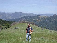 Michael
McGee on recon to establish RTK Base Station to control 14,000
acre ranch in Northern California
Michael
McGee on recon to establish RTK Base Station to control 14,000
acre ranch in Northern California 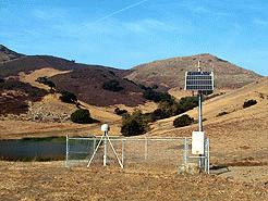 SCIGN CORS
Station at San Luis Obispo, CA: CORS stations are used extensively
SCIGN CORS
Station at San Luis Obispo, CA: CORS stations are used extensively